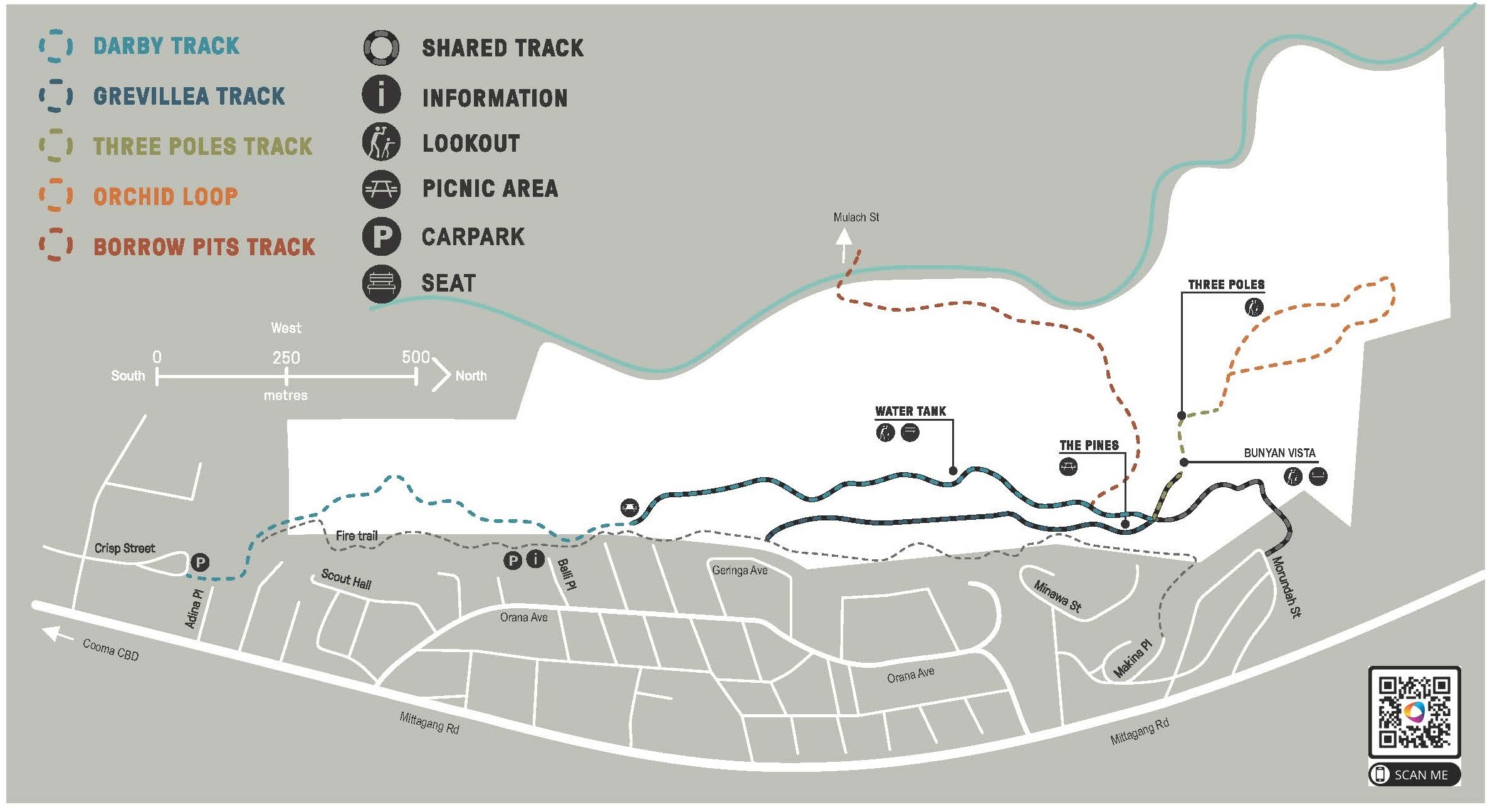
Darby Track
Grade: 3
Colour totems and signage: Blue
Access Point: Darby track at Crisp St distance to:
- Balli Place 1 km
- Water Tank 1.8km
- Three Poles 2.5 km
Starting at Crisp Street in the south, the Darby Track runs the length of the reserve, along the ridge and parallel to the fire trail. It showcases scribbly gum woodlands, rock outcrops, panoramic vistas, diverse floral communities, marsupials and bird life.
This walk can also be started at the Main Information board at Balli Place. Follow the blue totems along the Darby Track.
The semi-circle shape of ‘The Pines’ area at the top of the ridge was originally planted as a wind break for grazing.
At the Three Poles Gate, take time here to admire the Bunyan Vista from the natural rock lookout a few metres to the right.
Grevillea Track
Grade: 3
Colour totems and signage: Dark blue
Access Point: Grevillea Track from Geringa Ave distance to:
Access Point: Grevillea Track from Minawa Place distance to:
- The Pines (250m)
- Three Poles (500m)
- Crisp St (1.8km)
Branching from the fire trail at Geringa Ave and snaking to the east of The Pines, the Grevillea Track treats walkers to displays of woolly grevillea from spring to summer. The sweet-scented heath also flowers in the spring.
Three Poles Walk-Walkers Only area
Grade: 3
Colour totems and signage: Green
Beginning at the Bunyan Vista, this track links The Pines to the Orchid Loop providing views across Cooma Creek to the Lambie Street end of town. On the horizon, the basalt grasslands and the volcanic plugs of “The Brothers” can be seen. Take time to admire the view northwards to Bunyan and Bredbo from the rock lookout, Bunyan Vista.
From this point north, the environment is extremely sensitive and hosts a wide variety of rare native orchids in season and rare bryophytes.
Return can be via the same route with a variation along the Grevillea Track, Dark Blue totems and signs, or walk on to the Orchid Loop Orange totems and signs.
Orchid Loop-Walkers Only area
Grade: 3
Colour totems and signage: Orange
From late October through to the end of November, and again from March to late April, you may see local native orchids in flower. These ground dwelling orchids are sensitive to rainfall and fire and don’t appear regularly. Scattered throughout the reserve they are most often seen along this loop.
Please admire them but leave them to regenerate.
At the northern end of the loop this track continues along the ridge through inland Scribbly Gum woodland (Eucalyptus rossii) for another kilometre to the northern extremity of the Reserve.
Borrow Pits Walk
Grade: 4
Colour totems and signage: Brown
Access points: Mulach Street or The Pines
- (2km return) Walk in either direction
Branching from Darby Track, near The Pines, the track takes its name from a period when council borrowed the rich basalt soil for gardens and other uses. The track descends steeply through the gully, with many rock steps.
It passes the ruins of saddler JE Pretty Walker’s stone house, now an overgrown garden of irises, quinces and plum trees, to Cooma Creek where you may spy a platypus. The track finishes at Mulach St, the major western entrance to Cooma North Ridge Reserve. The ford may be covered with water and the rocks are slippery.
To extend this walk you can return to the CBD via Mulach St and Nijong Oval. This is approximately 2 km. Please take your time and enjoy our wonderful reserve.
In 2022, a Bushfire Community Recovery Resilience fund was used to upgrade and extend the steps and improve the drainage of the section of track from the ridge to the valley floor.
Morundah
Grade: 4
Colour totems and signage: Shared
Morundah to The Pines is 400m. Check the Trackhead at the crest of the ridge for these walk options.
Three Poles Trackhead at top of Morundah distance to:
- Three Poles (200m)
- Orchid Loop (300m)
- Balli Pl (1.2 km)
- Crisp St (2km)